User reviewed online profile of Waitakere Ranges Regional Park: Auckland region, New Zealand. Plan your adventure holiday to Waitakere Ranges Regional Park armed with information and reviews provided by experts and by users. Find out about when to go, how to get there, what to do, best season to visit, its wildlife, habitat and much more…
What to do in Waitakere Ranges Regional Park:
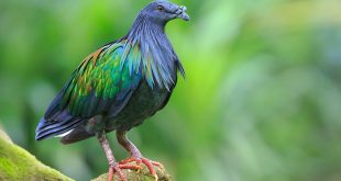
Wild Life: Morepork, Kingfisher, Shining Cuckoo, Tui, Kereru, Pied Tit, Green Gecko, Forest Gecko, Hochstetter’s Frog, Myna, Blackbird, Chaffinch, New Zealand Dotterel and Fernbird
Adventure: Abseiling, Swimming, Surfing, Tramping, Bushwalking, Fishing, Boating, Horse Riding, Running, Walking, Picnicking, Camping, Canyoning, Sightseeing
Where is Waitakere Ranges Regional Park:
Region:
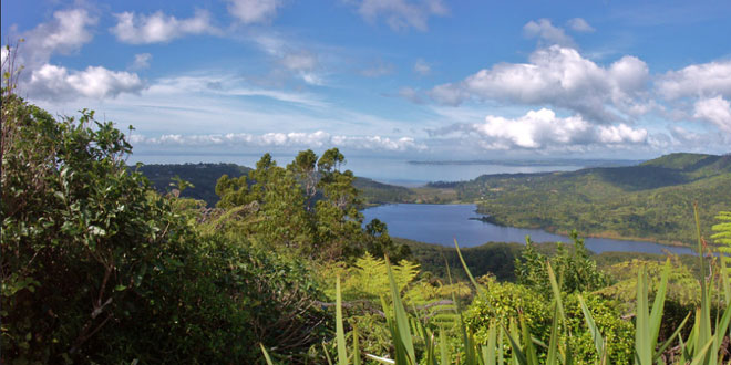
Location: Waitakere district, Auckland region, New Zealand
When & how to get to Waitakere Ranges Regional Park:
Best Time to Visit: to
Getting There: From Downtown Auckland there are several ways to access Waitakere Ranges Regional Park.
- Huia Rd 18km (25 min): Signposted from Titirangi and leads to the southern region of the Waitakere Ranges including Cornwallis, Huia and Whatipu. From Little Huia take the 7km Whatipu Rd to Whatipu.
(Caution: much of Whatipu Rd is gravel, winding and narrow). - Scenic Drive 28km (35min): Extending from Titirangi to Swanson, Scenic Drive passes through the eastern fringe of the Waitakere Ranges.
- Piha Rd 23km (30min): From Scenic Drive, this road crosses the heartland of the Waitakere Ranges to Piha Beach. Road access to Karekare and Anawhata range off Piha Rd.
- Te Henga / Bethells Beach 25km (35min): Te Henga Road starts from Scenic Drive and joins Bethells Road to lead around the northern area of the Waitakere Ranges, including the popular Cascade Kauri area, ending on the West Coast at Te Henga.
Nearest Town: Titirangi
Nearest Airport:
Nearest Railway Station:
Where to stay (Lodges / Guest Houses / Camps / Resorts / Hotels):
Accommodation:
Add a hotel: If you know of a hotel, resort, guest house or camp please add it here. If you own or manage a hotel or resort you can add it to the database for ‘Free’.
Climate & Weather conditions in Waitakere Ranges Regional Park:
Temp: c to c
Rainfall: 2000 cm
Altitude: 474 m
Other details about Waitakere Ranges Regional Park:
Established: 1940
Area: 160 sq km
Language: English and Maori